|
|
|
These Saxons met together to consider and discuss questions of common and general interest. Their meeting or assembly was not one of subjects or followers, but of freemen. After a while the farmers and others who were much occupied with their own affairs, got into the way of staying away altogether. Those who had more leisure, or talent for such matters, went. Thus was developed in a crude way a governing class. Whenever rules were made, unfavorable or obnoxious to the others, they would go, assert their rights, undo what had been done and adjust things as best suited them. Thus, from the earliest of these assemblies came the New England town meeting, from its later form then known as the Witenagemat, or the Meeting of the Wise Men, evolved the British Parliament and hence our National Congress and State Legislatures. And, incidentally, from the custom of those old Saxons to occasionally revolt against their rule makers, grew the right of revolution, sacred to the Anglo Saxon race. From it came the Magna Carta, The English Bill of Rights, a free British Parliament, the Mayflower Compact, the Declaration of Independence, and the American Constitution. The plantation is the same as the town, except with less powers and rights. The city acts under a Charter, granted it by the Legislature, having limited executive and legislative authority but no judicial power. The County is a governing power, its authority and duties, however, being less than those of either town or city. Its seat of government is called the Shire town, where are the Court House, Jail, the County Records and the offices of all the county officers all of whom are elected by the citizens of the County. |
| County | Brief History Narrative of the County | County Coordinator |
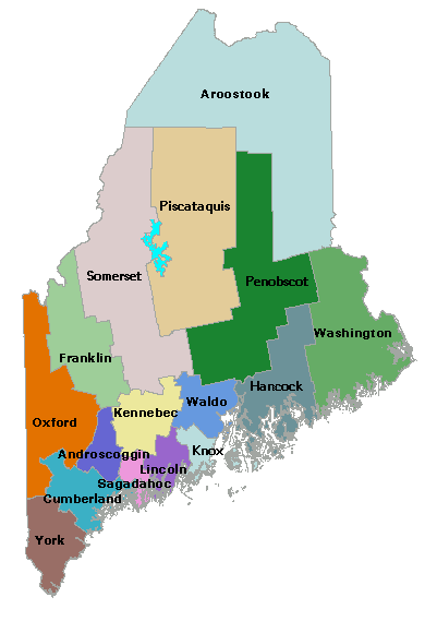
| Androscoggin | Incorporated March 18, 1854. Formed from Cumberland, Oxford, Kennebec and Lincoln. Contains 12 towns and two cities. Area 480 square miles. | |
| Aroostook | Incorporated March 16, 1839. Originally a part of Washington and Penobscot Counties. Enlarged March 21, 1843, by additions from Penobscot, and March 12, 1844, by additions from Piscataquis and Somerset. Contains 50 towns and 21 plantations. Area 6408 square miles. | This county is available for adoption. Please contactTina Vickery |
| Cumberland | Incorporated 1760. Originally embraced Franklin and parts of Oxford, Kennebec and Somerset. Contains 23 towns and three cities. Area 1014 square miles. | Tom Raynor |
| Franklin | Incorporated March 20, 1838. Formerly a part of Cumberland County. Contains 19 towns and five plantations. Area 1764 square miles. | Nancy Porter |
| Hancock | Originally a part of Lincoln County. Portions taken in 1816 to form Penobscot, and in 1827 to form Waldo. Contains one city, 33 towns and three plantations. Area 1390 square miles. | Tina Vickery |
| Kennebec | Incorporated February 20, 1799. Formerly a part of Lincoln County. In 1809 the formation of Somerset County took four-fifths of its territory; Waldo took four towns in 1827; Franklin five towns in 1838; Androscoggin four towns in 1854, Contains 25 towns, four cities and one plantation. Area 880 square miles. | Doreen Crocker and Tina Vickery |
| Knox | Incorporated in 1860. Named for General Henry Knox. Formerly a part of Lincoln and Waldo. Contains 15 towns, two plantations and one city. Area 327 square miles. | This county is available for adoption. Please contact Tina Vickery |
| Lincoln | Incorporated June 19, 1760. Formerly a part of York, Parted with some of its territory in the formation of Washington, Hancock, Kennebec, Waldo, Androscoggin and Sagadahoc. Contains 18 towns and one plantation. Area 520 square miles. | Linda Simpson |
| Oxford | Incorporated March 4, 1805. Formerly the northerly parts of York and Cumberland. The formation of Franklin took a large part of its territory and Androscoggin took two towns. Contains 35 towns, three plantations. Area 1981 square miles. | |
| Penobscot | Incorporated February 15, 1816. Formerly a part of Hancock. The formation of Piscataquis took 13 towns and over 40 townships. Contains 53 towns, eight plantations, three cities. Area 3254 square miles. | This county is available for adoption. Please contact Tina Vickery |
| Piscataquis | Incorporated March 23, 1838. Formerly a part of Penobscot and Somerset. March 12, 1844, a portion of its wild land territory was annexed to Aroostook. Contains 20 towns, four plantations. Area 3626 square miles. | Deb (Pelletier) Tajmajer |
| Sagadahoc | Incorporated April 4, 1854. Formerly a part of Lincoln. Contains nine towns and one city. Area 259 square miles. | This county is available for adoption. Please contact Tina Vickery |
| Somerset | Incorporated March 1, 1809. Formerly the northern part of Kennebec. Portions of it have been ceded to Franklin, Piscataquis and Aroostook. Contains 25 towns, 15 plantations. Area 3831 square miles. | This county is available for adoption. Please contact Tina Vickery |
| Waldo | Named in honor of General Samuel Waldo. Incorporated February 7, 1827. Formerly a part of Hancock. Territory enlarged January 22, 1828. Contains 25 towns and one city. Area 748 square miles. | Bill West |
| Washington | Incorporated June 25, 1789. Originally embraced a large part of what is now Aroostook. Contains 45 towns, four plantations, two cities. Area 2456 square miles. | Kess Campbell |
| York | [Sir Ferdinando] Gorges named what is now York County and all of his other Maine possessions, New Somersetshire. In 1658 when the inhabitants of Maine submitted to the rule of Massachusetts, she gave it the name of Yorkshire. It then extended to the western limit of North Yarmouth in Casco Bay. In 1760 the Counties of Cumberland and Lincoln were taken from it. Contains 24 towns, two cities. Area 957 square miles. | Tom Raynor |
Source: The Counties of Maine --- Town Government in Maine. Sprague's Journal of Maine History, Vol. 8, December 1920, No. 4, pages 205-207. | County | Court | Interactive | Libraries | |
| Maps | Military | Newpapers | Religion | Societies | Home |
 Copyright Notice: All files on this site are
copyrighted by their creator and/or contributor. They may be linked to
but may not be reproduced on another site without specific permission
from the MEGenWeb Project [[email protected]] and/or their contributor. Although public information is not in and of
itself copyrightable, the format in which they are presented, the
notes and comments, etc., are. It is however, quite permissable to
print or save the files to a personal computer for personal use ONLY.
Our very special thanks to Holly Timm for the creation of the MEGenWeb
Project graphic. The use of the Penny Postcard(s) in the title graphic and other pages within the MEGenWeb Project is used with permission of the Penny Post Cards a USGenWeb Archives Web Site. Copyright Notice: All files on this site are
copyrighted by their creator and/or contributor. They may be linked to
but may not be reproduced on another site without specific permission
from the MEGenWeb Project [[email protected]] and/or their contributor. Although public information is not in and of
itself copyrightable, the format in which they are presented, the
notes and comments, etc., are. It is however, quite permissable to
print or save the files to a personal computer for personal use ONLY.
Our very special thanks to Holly Timm for the creation of the MEGenWeb
Project graphic. The use of the Penny Postcard(s) in the title graphic and other pages within the MEGenWeb Project is used with permission of the Penny Post Cards a USGenWeb Archives Web Site.
|
| State Coordinator ~ Tina S. Vickery. SPECIAL NOTE: Tina Vickery is ill at this time and Betsy Mills will be serving as a temporary contact until she is able to return. Special thanks to David Colby Young, Maine's previous State Coordinator. |
 Like the other
New England States, the town, is the unit of the state government of
Maine. Its powers and privileges are prescribed by laws enacted by the
Legislature of the State. Within these limits the rights of the
individual are absolutely secure. He is, under this form of town
government, a sovereign in, fact as well as in theory. His only ruler
or dictator is a majority of one of his peers. It is a pure democracy.
It was established here by the Pilgrims and the Puritans, a heritage
to them from our ancestors, the ancient Saxons.
Like the other
New England States, the town, is the unit of the state government of
Maine. Its powers and privileges are prescribed by laws enacted by the
Legislature of the State. Within these limits the rights of the
individual are absolutely secure. He is, under this form of town
government, a sovereign in, fact as well as in theory. His only ruler
or dictator is a majority of one of his peers. It is a pure democracy.
It was established here by the Pilgrims and the Puritans, a heritage
to them from our ancestors, the ancient Saxons.